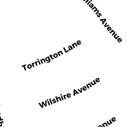
9 TORRINGTON LN
Owner Information
MCKENNA WILLIAM H
9 TORRINGTON LN
WESTFORD, MA 01886


Property Details
9 TORRINGTON LN is classified as a Single Family Residential (Ranch).
The primary structure on this property was built in 1967. There are 1,250ft2 of built area within this property. There is 1,250ft2 of residential/living space within this property. This property is listed as having 5 rooms.
9 TORRINGTON LN is valued at $324,500. The land is valued at $208,100 and the structures are valued at $116,400.
This property is in Zone RB. Confirm with local Zoning Board authorities to ensure there are no overlays or other easements on this property.
The most recent deed for 9 TORRINGTON LN is recorded at the local registrar in Book 2379, Page 152. 9 TORRINGTON LN was last sold on Friday, August 10, 1979 for $48,000.
Assessment data from fiscal year 2021.
Flood Data
According to the FEMA National Flood Hazard Layer, this property does not appear to be in a flood zone. It may also be in an area not yet reviewed. Nonetheless, confirm this information prior to taking any action.
To view the flood hazards around this property, create a FEMA "Firmette" Map of the area around 9 TORRINGTON LN.
Broadband Internet Providers
| Provider | Type | Bandwidth (mbps) | |
|---|---|---|---|
| HughesNet | Satellite | 25 | 3 |
| GCI Communication Corp. | Satellite | 0 | 0 |
| Comcast | Cable | 1000 | 35 |
| Verizon New England Inc. | Fiber | 940 | 880 |
| Viasat Inc | Satellite | 100 | 3 |
| VSAT Systems, LLC. | Satellite | 2 | 1 |
Broadband service provider data from December 2020.
Adjacent Properties
- 10 WILSHIRE AVE
Single Family Residential owned by DEMERS DONALD - 7 TORRINGTON LN
Single Family Residential owned by WALSH CHARLOTTE D - 12 WILSHIRE AVE
Single Family Residential owned by MURRAY REALTY TRUST OF 2001 U/D/T 3/20/01 - 11 TORRINGTON LN
Single Family Residential owned by WESTBERG FAMILY REVOCABLE TRST 9/5/02